


Thomasville Students Participate in Environmental Research Project on Heat Islands
In southern Georgia, AP students in Richard Faucett's environmental science class participated in a citizen science research initiative happening out...
2 min read
#UrbanHeatATL
Get involved: urbanheatatl.org
Extreme heat is the leading cause of weather-related deaths in the United States, more than hurricanes and tornadoes combined.
Disproportionately affecting the most vulnerable community members, heat extremes are particularly deadly in densely populated urban centers such as Atlanta. In many other cities, maximum urban heating often occurs in locations that reflect the compound impacts of historic racism, including redlining. The urban heat island effect is real and important to understand.
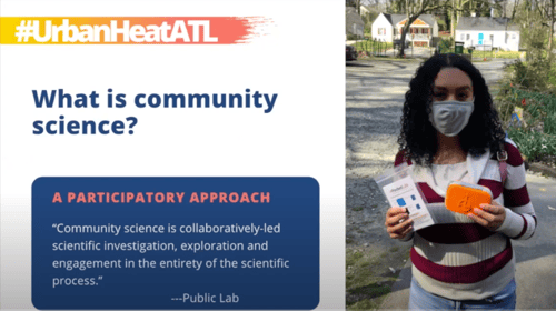
They are sending community scientists handheld PocketLab sensors, and asking them to track temperature by foot or by bike over several months. We’re using these data to map urban heat islands in Atlanta, especially as they relate to the impacts of climate change on frontline communities, and the role of urban greenspace, city planning, and energy burden in shaping environmental justice priorities.
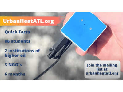
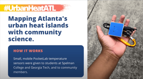
Roughly 40 students from Georgia Tech and Spelman College will serve as data collectors for the urban heat campaign using a PocketLab sensor that they will connect to a smartphone app with guidance from the UrbanHeatATL team and record urban air temperature data from around the city. Understanding this data is the first step to mitigating urban heat islands.
The UrbanHeatATL team is a collaboration between the Spelman College Environmental and Health Sciences Program, the West Atlanta Watershed Alliance, the Partnership for Southern Equity, the Georgia Tech Center for Serve-Learn-Sustain, the Urban Climate Lab and the Georgia Tech Global Change Program and the City of Atlanta. The project launched as part of the Atlanta Science Festival.

Because heat extremes disproportionately affect the most vulnerable community members, and are particularly deadly in densely populated urban centers such as Atlanta, the UrbanHeatATL team is launching its urban heat mapping initiative as part of the Atlanta Science Festival. Understanding how heat islands impact the city is the eventual goal.
The interactive citizen science event will investigate temperature throughout Atlanta, by lending PocketLab Weather and Voyager sensors to students, who will track temperature over several months, through the hottest months of summer, when urban heat islands are the most pronounced.
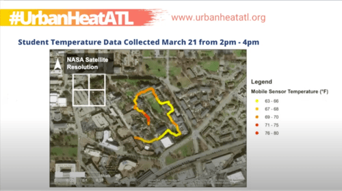
Understanding where the heat islands are will help understand how a heat island is formed. And due to the nature of urban environments, how are nighttime temperatures effected by these islands?
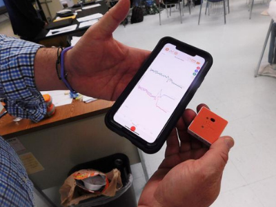
The PocketLab Voyager (red sensor) and the PocketLab Weather (blue sensor) are hand held, bluetooth operated sensors that record data instantaneously through a smartphone, tablet, or laptop. For this project, the citizen scientists are using the temperature probes to map the heat islands across the city as they move around. The great advantage to these sensors is that they essentially replace boxes full of lab equipment with a device small enough to fit in your pocket. Both sensors have a variety of other functions including humidity, dew point, force of motion, gravity, etc. Learn more here: https://www.thepocketlab.com/sensors
The launch of the UrbanHeatATL project happened at the Atlanta Science Festival. At this panel discussion, which features both climate and community experts, they showed preliminary data, and discussed how urban heat islands tie in concepts related to climate change, urban greenspace as instruments of community resilience, energy burden, and redlining. Watch the video below.
Watch the UrbanHeatATL team online panel discussion through the Atlanta Science Festival. Learn the science behind urban heat islands and their relationship to climate change & environmental justice. Learn how they are using PocketLab sensors to log the data being used in this project. Discuss solutions with experts who are advancing climate justice through a lens of racial justice and equity. Discover how community scientists are mapping temperature extremes in Atlanta with high-tech sensors, and learn how to get involved!
Use PocketLab Notebook to perform similar research with your students.
You can use a PocketLab temperature sensor to log your data or any kind of temperature sensor and then map your data and findings!
Learn more about implementing large-scale projects in your organization here.
Click here to access the heat island lesson in Notebook.
Learn more about UrbanHeatATL at https://urbanheatatl.org/
In southern Georgia, AP students in Richard Faucett's environmental science class participated in a citizen science research initiative happening out...

DonorsChoose helps public school educators get the classroom supplies they need to deliver exceptional education. Read on to find out if you’re...

NGSS standards: (Physical Sciences), (Forces and Motion) The PocketLab team knows that our products can be used for some very cool experiments. But...